Wednesday, September 28, 2016

Return to the Nullarbor: by train across the lucky country

Indian Pacific at Two Wells, South Australia
In 1977 Marg and I decided that the cheapest way to finish our two year OE was by flying from Jakarta to Perth, hitching across Australia, then flying from Sydney to Auckland. Easy eh? Our first driver out of Perth enlightened us "Yeah, you'll have to get a ride across the Nullarbor. Took me two weeks to get a ride when I did it". Our fixed date flight from Sydney was in 10 days, so we clearly needed some good fortune to cross the "Lucky Country". At dusk at Kalgoorlie on the edge of the Nullabor, our first good fortune arrived in the form of a truck that stopped at every place between there and Eucla on the South Australian border: 900 km and 6 stops. Our second good fortune was a mining worker from the northwest who'd heard that his daughter was sick in Melbourne, hopped in his car and drove across Australia, picking us up in Eucla to keep him awake. So rather than being stranded in the outback, we returned to NZ and established home, careers and a family.

Lift across the Nullarbor, 1977
39 years later we decided to repeat the trip in reverse. Rather than hitch, we opted for the Indian Pacific train. We'd taken the Ghan from Adelaide to Darwin in 2011 and found that watching Australia go by was a satisfying travel experience. I'd taken the Overland from Adelaide to Melbourne in 2014, so the Indian Pacific completed the trifecta.

Despite it being Marg's Gold Card birthday, our age can't have been obvious when we checked in for the flight to Sydney; we were asked if our bagged Tern folding bikes were baby strollers . We settled into the Rendezvous Hotel on the Rocks, enjoying the promised terrace view of the Opera House and the Harbour Bridge. Next morning, we discovered that Air New Zealand baggage handling had bent the chainring on Lucie, Marg's bike. The nail file on my Leatherman didn't give enough leverage to realign it, so we headed out for breakfast, pondering how far away the nearest bike shop was. A tradie was working on the street. "Ah, you wouldn't have a shiftgrip you could lend us?" "Sure, mate, I'm off for brekkie. Just chuck it in the back of the ute when you're finished"

With Lucie's gear changing restored, we headed up to the cycle track on the Harbour Bridge - bikes get one side, pedestrians the other. It was peak commuter time, with numbers that would gladden the hearts of Skypath promoters. On the stairs on the north side a security guard was posted to keep order as bikers hiked up the stairs - except for one fit soul who stormed up the near 1:1 gradient centre lane.


We explored Milsom's point and Lavender Bay finding a series of sculptures by the trail.
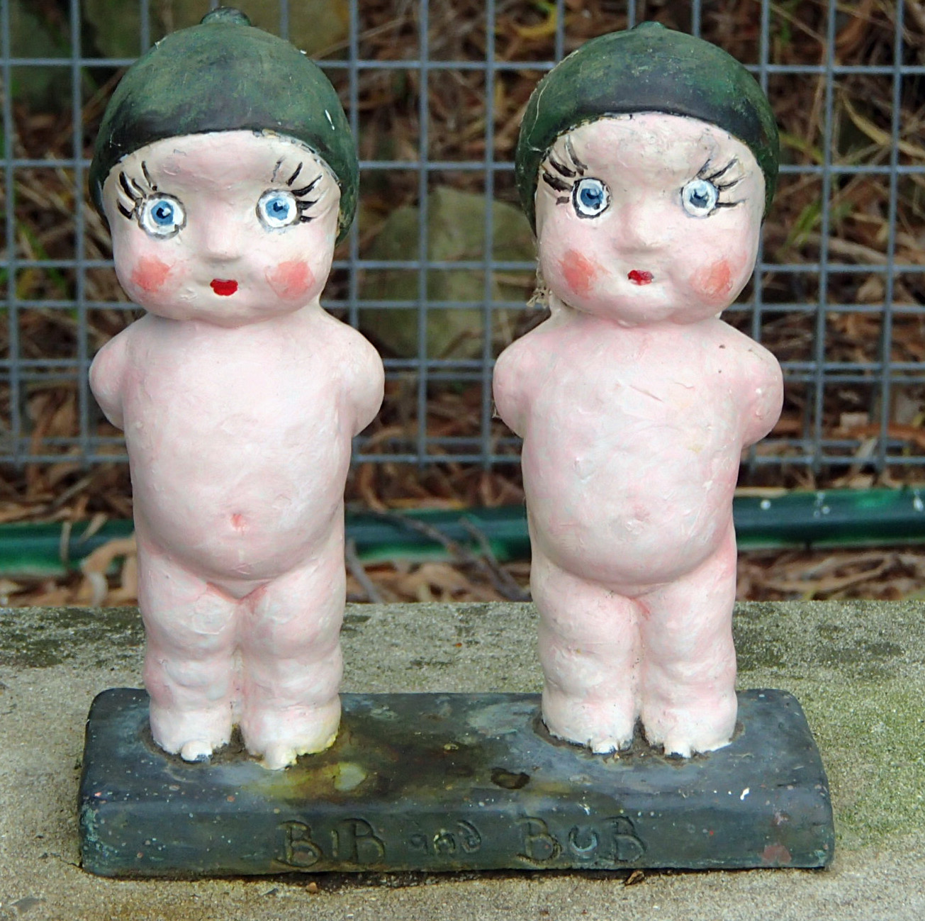
Bib and Bub, iconic Australian Gumnut babies

A replica Luna Park lurks in the bushes
Marg checks out the real Luna Park
A ferry took us over to Darling Harbour, and we biked back around Barangaroo Reserve to the Rocks, passing a roundabout with a sculptural commentary on traffic, and the bike friendly cafe BarCycle where customers can practice their pedal ankling while sipping their lattes.
Barangaroo shared path


A quick loop around the Opera House and the Royal Botanic Gardens, lunching with the resident ibis, then we checked out the cycle lanes on the way to the station.
Tern touring the Opera House
Marg at Mrs Macquarrie's chair, Botanic Gardens
Two way separated bike lane, Castlereagh St
The Terns were checked through to Perth, and we settled in to our Gold Class compartment, home for the next four days.


We had a generous couch that converted into the lower of two bunk beds at night (and yes, there was a chocolate by the pillow every night!) and an en suite toilet and shower. Marg was a bit disconcerted to discover that we'd be travelling backwards, but it turns out that on the side trip into Adelaide, the 28 carriage train comes out the other way, so you end up doing half the trip forwards and half backwards.

We joined our fellow passengers in the lounge car as the train wound up through the Blue Mountains. We tried not to overdo the unlimited complimentary drinks. An English fellow passenger spent the evening taking selfies of himself with a soft toy kiwi, clearly confused by geography. Our turn in the dining car came as the sun set on the Megalong valley.

We woke to the arid red outback, though pools of water showed that there had been recent rain. We rolled into Broken Hill for our off train excursion to the Miners' Memorial, a gaunt sheetmetal structure on a hill overlooking the town, with plaques recording the grim human cost of mining, such as 12 year old John Armitt, asphyxiated by dynamite fumes in 1890.
Indian Pacific from the Miners' Memorial, Broken Hill
Back at the train with 20 minutes before the scheduled departure, we thought we'd go for a walk around the block. However we were pursued by two train staff  "We're locking the doors in 5 minutes!" With several hundred passengers to keep tabs on, and the risk of losing clients in the outback with the next train not due for a week, the protectionist approach isn't surprising, though it could be significant that until recently the rail company was owned by prison operator Serco.

At Two Wells, 60km out of Adelaide, we changed to bus for the Barossa Valley. The land ownership in the area reflects Australian immigration: from the original aboriginal occupiers, to British settlers, German immigrants such as the Seppelts who established the wineries, then Italians and now Vietnamese horticulturalists. We passed under the Long Tan bridge on the way to the Seppeltsfield Winery, where the chef explained the wine and snack matches laid out for us in the cavernous storage shed.

In the museum, a minute book recorded the important decisions in the early days of the German community "That we hold our Xmas Party...It was suggested that we have more sport this year mainly for the children... Ask that Mr H Wendt be Father Xmas". We left through avenues of date palms, planted as depression employment for the Winery staff, though it's only recently that the enterprising chef has discovered that while the dates don't reach full maturity in the South Australian climate, the immature fruit can be pickled to produce capers.
Brazier for heat treating barrels, Yalumba cooperage
At the Yalumba Winery cooperage we saw how time, heat and steam make staves of imported oak into wine storage. On a larger scale, Yalumba used to store wine in big underground vats, the concrete walls sealed with paraffin. These have now be converted to elegant dining rooms, where we had our dinner before being bused into Adelaide to rejoin the train.

Next morning we were still in South Australia, but definitely outback. The scrubby landscape occasionally sported pink wildflowers, and nondescript buildings topped with solar panels, their purpose not apparent apart from providing nests to storks.


By lunchtime we'd reached Cook, a ghost town where a well meaning group had defied the Latin meaning of Nullarbor (no trees) by planting 600 trees around the town, but only a few survive. In an attempt to retain services, the town hospital was advertised with the slogan "If you're crook, come to Cook". Now only a few railway workers live in the town.

The WA/SA border obelisk flashed by in mid afternoon, and at dusk we pulled into Rawlinna, the rail halt for the eponymous sheep station. Tables were laid out alongside the carriages, warming braziers lit, and a roast meal was served up under a Milky Way made visible by the lack of city lights.

In the night I woke during a long stop at Kalgoorlie station, the ornate Victorian ironwork contrasting with a sleek inter city train parked across the station platform. Later the sun came up as we progressed through gradually more arable landscapes, kangaroo giving way to sheep and alpaca (apparently alpaca protect the sheep from foxes), scrub to bright yellow fields of canola.

By mid afternoon we'd reached Perth, and the next stage of the adventure. While it was more expensive than our last crossing of the Lucky Country, the Indian Pacific gave us four days of travel experience, great food, attentive staff, and a true sense of how big our western neighbour is.


Monday, June 6, 2016

Stairway to Heaven (continued)

Looking south to Tapuenuku from the high point of the escarpment track
What's the most popular section of Te Araroa, the pathway from Cape Reinga to the Bluff?  The Tongariro Alpine Crossing, springs to mind, but a new section, the Paekakariki Escarpment, may be set to rival this.

Back in 2014, I walked the "Stairway to Heaven" south from Paekakariki along the escarpment that rears up above the railway line and the Centennial Highway. It was incomplete, but in April 2016 the trail was completed through to Pukerua Bay.

Surface pressure map, Queens Birthday Sunday
With a Queens Birthday high on the weather map, Marg and I set out to complete the trail. We got the train (which turned out to be a bus replacement) to Pukerua Bay. Marg doesn't quite yet qualify for a Gold Card but invested a Day Rover. The bus pretending to be a train took us on an interesting tour of Tawa backstreets before climbing to Pukerua Bay, cunningly giving us a 100m altitude gain for a "mainly downhill" northerly trip through to Paekakariki. Any doubts about where to go from Pukerua Bay station were dispelled by simply following the crowds of day walkers. Along Sea Vista drive on the southern side of the station, to the redundant Muri station platform, and alongside the train tracks carefully isolated by fences and warnings of the danger and fines exacted on transgressors. Soon we were on the track proper, climbing up and down gorse clad slopes.

Marg started counting steps but gave up in the hundreds, then started counting people, reckoning over a thousand for the day.

Two indented gullies are crossed on sturdy suspension bridges, circular cable structures stabilising them against gales sweeping in from Kapiti. While the track is of good standard, it's narrow and some people were clearly a bit uncomfortable on the steep slope, although scrub would likely stop any fall. The long staircases alternated with sidling across the face. I was pleased that I'd taken two poles to ease the strain on my newly irradiated hip, which gave me the excuse to slow down, alternating pole placement with foot movement. Solid pre-rusted iron girders were thrust into the ground as kilometer markers, ten in all.

At the high mid point, around 5km from each end, and 200m above the sea, we stopped for lunch at a semi circle of seats looking out to sea. Tapuenuku loomed above Pukerua Bay to the south, and the bulky smudge of Ruapehu was visible to the north. We descended on more staircases, at one stage a kārearea contouring the hillside swooped over the track metres above my head. As we crossed patches of  kohekohe forest we heard tui, and and the wingflap of the occasional kereru. The last kilometre or so was close by the railway line, then we ducked under the SH1 bridge and on to Ames St to Paekakariki, five hours from Pukerua, somewhat more than the official 3-4 hours.

A debate about whether to rush for the 2:45 "train" or wait for the 3:15 was short circuited when the bus masquerading as the train stopped in the main street to load up with escarpment walkers. So many in fact that the driver announced he didn't have the ability to collect fares so we were getting a free trip. Thanks, GWRC!

Close to major urban centre, easily accessible by public transport, with spectacular views, the Escarpment trail is likely to earn its nickname "Stairway to Heaven" and become one of the most popular sections of Te Araroa.

Thursday, March 3, 2016

In the wake of Abel Tasman

As I went to launch my kayak at the Marahau boat ramp, a tractor driver expertly backed a boat trailer into the water. "Got a boat to pick up?" I asked "Got 14 to do in the next half hour" he replied, jumping off the tractor and running back up to the parking area to collect the next tractor and trailer as a water taxi ran up on to the trailer. In a moment the tractor driver had a trailer in place for a second water taxi, jumped onto the first tractor and drove the first boat up the ramp. I hurried to get my kayak out before I disrupted the smoothly oiled operation, part of Abel Tasman's burgeoning tourist industry.

Marahau local
"Canoeing along the coast is becoming increasingly popular" according to my 1989 edition of the Abel Tasman National Park Map. I'd tramped and sailed the Abel Tasman coast, but had never kayaked it. Back in Wellington I'd spotted a good weather window with no meetings, so booked the car on the ferry and drove across to Marahau. I set up base camp at Mcdonalds farm, a pleasantly shady camping ground up the valley from the coast, populated by Llamas and the remnants of the summer camping rush. I chatted to a fellow camper with an eBike, which he used to commute between his Moutere home and his permanent camper van at the camping ground.
Base camp at Marahau
That first morning I headed south to giant spheroid of Split Apple Rock, and on to Kaiteriteri. As I paddled through the gap between the shore and Kaka Island I met a squadron of tourists heading north, the first of many encounters confirming the 1989 prediction.
Doing the splits on Split Apple Rock
After coffee (on land, despite a floating coffee bar moored off the beach) I headed north again to Fisherman Island, beaching on golden sand along with several groups of kayakers, and a family picnicking on hors d'oeuvres ferried across from their speedboat. The clear water was inviting, so I snorkeled along the rocks, spotting paua and starfish along with fish. Back on shore, the other kayakers said "did you feel the earthquake?" Fortunately, I hadn't - I suspect knowingly snorkeling in an earthquake would be scary.
Fishermans Island
I paddled around Adele Island, trying not to disturb the seals slumbering on the rocks, and marveling at the birdsong blasting out from the predator free bush. Back when Cook visited the area, the noise of birds was so loud they couldn't sleep on shore. Places like Adele, where the threat of predators is being removed, have some hope that we'll be able to experience pre-European NZ, perhaps having to use ear plugs when we camp! At the beach on the western side of Adele, I spotted a notice on the shore that I couldn't quite read, so landed to check it out. The sign turned out to to be one that politely suggested you didn't land, and if you did, to carry out a full fumigation and pest eradication programme on your boat.
Kayaks being repositioned by water taxi
A feature of the Abel Tasman coast is a reliable northerly breeze that picks up in the afternoon, so I rode this back to Marahau. Water taxis zipped past, laden with kayaks being repositioned for people taking a kayak + tramp option for experiencing the park. At the beach, now with low tide a couple of hundred metres from the boat ramp, I foolishly spurned the offer of a lift on one of the fleet of kayak trailers. I attached my trolley wheels and trundled the kayak up to the carpark, finding the sand less hard packed than I'd imagined. To cap it all, at the car I realised I'd left the stand I used to help load the kayak onto the trolley back at the shore, so got to walk back again.

After a beer from the chilly bin at Base camp, and Terning down the road to a fine pino gris and pizza, the day seemed to be complete.

The next day I decided to see how far north I could go before the afternoon breeze kicked in. An earlier start at low tide meant trundling the kayak across the mudflats to the shore, but soon I was heading up the coast with a slight Sou'Easterly pushing me along. Lots of inviting beaches dotted the coast, but I decided on Watering Cove for my morning scrog stop - the beach was slightly sweltered from the swell. I chatted to the multinational hiking group filtering water and packing up their postage stamp sized camp, then headed around Pitt Head to Torrent Bay. A yellow blob floating past turned out to be Linus and Snoopy, presumably abandoned by a family yacht.
Snoopy and Linus after rescue
I kept going north to Bark Bay. Back in the 80s we'd camped here, thinking it crowded with 10 of us, and generously distributing our tents and flies around to discourage the following party of scouts from setting up camp on "our" beach. Now DOC limits campers to 40, kayak guides are continuously marshalling their fleets in and out of the beach, and a row of yachts occupy the back of the sandspit. A young camper was noisily dissatisfied with his parents choice of holiday - I handed on Linus and Snoopy as a pacifier, which was effective for at least for a few minutes.
Kayakers enjoy their isolated wilderness experience, Bark Bay
After lunch I picked up the afternoon breeze and headed back south. At the mouth of Torrent Bay, I found a deserted beach to snorkel from - despite the crowds on accessible beaches, there are still quiet spots, although we can't afford to lose access to beaches such as Awaroa. I passed Adele close enough for the birdsong concert, and headed down to Marahau, following a guided party that had rafted up and deployed a tarp as a sail to get them home.
Tarp sailing back to Marahau
While the kayaking had been great, my hips were telling me that three nights camping was enough, so I packed and headed back to Wellington, and a home that I didn't have to crouch to get into.

Thursday, January 21, 2016

Clarence Clear Water Revival


How can baby boomers with failing hips and knees get the wilderness experience of tramping without the tedious business of putting one foot in front of the other for days on end? An email from ex Auckland University Tramping Club mate Alan had the answer: a five day rafting trip down the Clarence River. A few months and many emails later, Alan had organised a party of ten and a rafting company to take us on the adventure.

The Clarence River is the eighth longest in Aotearoa, 230 km from its source at Lake Tennyson, making its way north east between the Inland and Seaward Kaikoura ranges, before turning to reach the Pacific Ocean just north of Kaikoura. It's true wilderness country, with only a few four wheel drive tracks offering access to the outside world. Part of it lies in the Ka Whata Tū o Rakihouia Conservation Park.

We gathered at Hanmer Forest Camp - in itself a trip down memory lane, staying in two bed forestry workers huts. Next morning the Ultimate Descents bus arrived with three rafts in tow, and we were on our way to the Acheron confluence, to start the rafting journey. Dressed up in life jackets and helmets, we set off in our two passenger rafts, accompanied by Whio Nui, the Big Blue gear raft carrying our overnight gear in large drybags.
Tim and Alex take raft Karearea down to the river at Acheron
Alex gives us a crash course in basic rafting skills


Although our guides Alex and Ariel handled the general direction and speed of the rafts, we were the reserve power for the raft, tweaking the accelerator with the commands "back" "forward" and "relax". The latter, which meant to stop paddling, often because were heading for rock, was sometimes emitted in the same tone that actors in medical dramas use for "Clear!" as a patient gets a life saving defibrillation.


Team Karearea: Bernard, David, Ariel, Sheryl, Jocelyn.
Whio Nui aground
The river was relatively low, making for more obstacles as we headed through the first gorge. At one stage we formed a queue behind Whio Nui which, despite Sonny's steering skills, had obstinately gone though a gap sideways and got stuck. However this and other obstacles were soon overcome - sometimes by the "Clarence Bounce" where everyone on a grounded raft jumps up and down to free it.
Big Eddy campsite
We camped at Big Eddy, a willow-skirted backwater with an established camp, and our guides got to work on lighting a fire for a brew, and establishing the latrine with a guide rope and helpful yellow bag to indicate occupied status. Given that I didn't have to carry my gear, I'd decided to eschew the closed cell foam part of the wilderness experience, and slept soundly on a Warehouse LiLo in a generous sized tent.

Team Kereru paddle hard for the camera
Next morning we carried on down river, the occasional rapid providing variety as we observed the wildlife: pied stilts, paradise ducks, herons lower down - and frequent herds of goats clambering the hillsides. A hole in one of Whio Nui's pontoons necessitated an early lunch stop opposite Palmer Hut, accessible by four wheel drive from the inland Kaikoura road, which got me thinking about possible combined mountain bike and raft trips - perhaps a future adventure. Patching completed, we headed down to Quail Flat, where Solana introduced us to the traditional rafters' dessert of chocolate stuffed bananas baked in the campfire.
Solana demonstrates chocolate stuffed banana
I went for an early morning walk up to the Quail Flat homestead, a 1870's cob cottage, still in use by farm staff. Alongside, the old shearing shed has been restored by DOC.

Interior of Quail Flat homestead
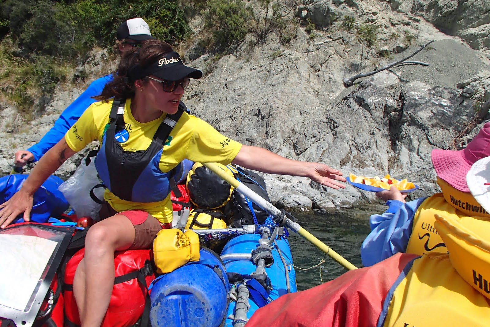
Solana doles out mid stream treats from Whio Nui
The day turned sunny and hot, and we got views of Alarm and Tapuenuku on the Inland Kaikoura ranges. David and I had climbed "Tappy" in 1972, and of course a view of the snow capped peak is a feature of biking the south coast of Wellington on a clear winter's day.
David downs paddle to photograph the Clarence side of Tapuenuku
We were glad of a swim at our lunch spot near Goose Flat, though less enthusiastic to be battling wind in the afternoon as we made our way to the DOC hut at Snowgrass Flat. Robins explored our gear while Solana topped off a generous meal with a camp oven crumble.

A glance at the Snowgrass Flat hutbook showed that packrafting in individual lightweight rafts has become a popular way to navigate the river - following the lead of John Mackay and Piers Maclaren who went down the river in the 1970s on "chariots of tyre", an adventure recounted in John's 1978 book Wild Rivers.

Next morning marked the end of the fine weather. We breakfasted in the rain, and broke out the wetsuits for the first time on the trip. A small hole in the meticulous planning appeared - we'd run out of toilet paper. However this helped us to remember our youthful adventures - I recalled the AUTC trip leader who only took one roll for a ten day trip, doling out two sheets at a time on application.

Red Peak rendered in rock
As the river cuts through the rock, it reveals the tortured patterns of metamorphic folding. At one point, a very creditable reproduction of the Red Peak flag design appears, created geological aeons before the 2015 flag consideration project.

As we descended the valley, cabbage trees and Kowhai started to appear, along with seagulls signalling the approach of the coast. At Boundary Stream, where the valley opens up, we made our final camp, dining on camp oven corn bread and chili, followed by pear topped cheesecake. Solid rain during the night made us glad we were no longer in AUTC 6'x8' japara tents, but turned the river brown with mud, and pushed the tethered rafts in towards the shore.
Ruth, Alan and Juliet supervise the chili, Boundary Stream camp
The higher river, and difficulty seeing obstacles in the muddy water, meant it was time to don helmets and wetsuits again. But we raced down the flats without incident to the final challenge, where Ariel found a perfect line past concrete and steel flood protection works debris, and delivered us to the take out point beside the SH1 bridge. For lunch Solana created a final culinary highlight, fresh sushi.

So is rafting the new golf? Maybe not, but in the hands of an expert guiding team it provided a unique wilderness experience where we could relive our youthful wilderness adventures without challenging our failing bodies too much.


More photos of the trip on Flicker


Tuesday, December 1, 2015

Terns on the Trail: Otago Central Rail Trail


"What? You haven't done the Rail Trail?" was a common response when I mentioned that we were going to bike the Otago Central Rail Trail. In fact I'd done part of the trail with "The Men of Steel" mountain biking group (which with increasing age and joint replacements is now "Men of steel, titanium, and surgical bioceramics"); and Marg had cycle toured Central Otago when there were actual trains on the Rail Trail.
I could claim family history of travelling in the area: my grandfather had spent the 1890s touring the gold workings in an effort to convert the Chinese miners to Presbyterianism.

But we hadn't got around to doing the actual "Rail Trail" package.

We decided folding bikes would simplify the logistics of the Rail Trail, so a fine spring morning saw us hopping on the Terns at Queenstown Airport, next to the bike assembly stand that bizarrely needs a notice asking that it not be used as an ashtray. We had most of a day before the shuttle left for Clyde, so pedalled around the Lake Shore to Kelvin Heights, passing the Kawarau Falls bridge: due to become a cycle bridge when a new road bridge is built to hasten tour buses on their way to Milford Sound.
Marg and (sculpted) wildlife, Kelvin Heights
The rugged tussock slopes of Peninsula Hill now sport modern apartment blocks. Outside the Hilton Hotel we admired the ChargeAbout rental Moustache eBikes, but decided to stick with unassisted pedalling on this trip.

From Kelvin Heights it's only a few hundred metres across the water to the Queenstown side, so we phoned up the water taxi; although we lost the "they're baggage not bikes" argument, costing us $40 for the short trip with our folding bikes. After a coffee at the elegant Victorian Bathhouse on the Lake shore, it was time to get the shuttle, again not being able to persuade the driver that the Terns were baggage. Lesson: always pack the folding bikes in their bags. However it was a fine trip through to Cromwell and Clyde, enlivened by our driver's efforts to dob in a driver "of Indian or Pakistani persuasion" who was travelling at less than the speed limit and occasionally touching the yellow line. The gale blasting down Lake Dunstan made us glad we hadn't tried riding to Clyde from Queenstown, instead starting by riding down the river trail on the true right of the Clutha from Clyde to Alexandra.
River Trail to Alexandra
"Snow" blossoms on the river trail
Trailside furniture
At Alexandra we checked into the "Middle Pub" - actually now the end (or "bottom" in local parlance) pub, since the original end pub has been sacrificed to a risen Clutha. That night the weather turned, with a gale like an express train blasting the hotel's garden furniture across the road. Next morning we tarried until the rain had eased to drizzle, then set off along the Rail Trail proper as it skirted the heather fields of Tucker Hill, where the gold miners had barely made enough to pay for their meals, let alone accumulate the fortunes they dreamed of.

Gents toilet, Chatto Creek
Jonathan Kennett of Nga Haerenga had told me that the Rail Trail was a "mature" trail: most of the required services have been developed, and sure enough morning coffee time coincided with the charming Chatto Creek tavern, where a notice warned us not to feed the gluten free donkeys. Tiger Hill was well within the gear range of the Terns so we had no trouble making Pitches Store in Ophir for lunch as sun started to replace drizzle. After a loop over the historic O'Connell bridge, we headed up the straights to Lauder and the tunnels and viaducts of the Poolburn Gorge, making the Hayes Engineering works just before closing. Ernest Hayes was a classic kiwi inventor.
Toy car, in its own garage, Hayes home.
As well as creating a wire strainer that his Hannah wife peddled (and pedalled) around Central Otago on her bike, Ernest added lots of technology to their home, including an early home entertainment system that enabled music to be broadcast to all rooms in the house.
Pitches Store, Ophir
At the Old Store B&B in Oturehua we discovered another aspect of the Rail Trail infrastructure: concerned that Oturehua Pub was the only place to eat, we trotted across the road to book a meal. "That's OK - you're already booked in". The Rail Trail has a bush telegraph auto booking system.

Idaburn Dam
Next morning I explored the Idaburn dam, where Black Swans shepherded their fluffy cygnets on the far side. Then we did the final climb of the rail trail to the summit, which coincides with the 45th parallel, and the descent to Wedderburn and its iconic goods shed. Grahame Sydney must wish he had a dollar for every tourist photograph imitating his painting.

Ranfurly Manse, 1960
Wall mural, Ranfurly
At Ranfurly I sought out the Presbyterian Church and Manse where I'd stayed on a visit to my cousins in 1960 - still on the edge of town, though more protected by trees. On to Waipiata, where the trail starts to bend again as it follows the Taieri River to Hyde and the Otago Central Hotel. The war memorial in front of the hotel chronicles the gradual decline of the town - a dozen names from WW1, only two for WW2.
War memorial and hotel, Hyde
Fencepost bikes, Rock and Pillar
On the last day we parallel the snow dobbed Rock and Pillar range as we head down the Strath Taieri plain, past the dreadful bend that in 1942 a sleeping train driver took at 120km/hr, resulting in the deaths of 21 passengers. Middlemarch marks the end of biking, as we fold and bag the bikes - no arguments about bike charges - for the goods car of the Taieri Gorge Railway and Dunedin.

So we've finally done the Rail Trail. Surprisingly, it didn't feel like an ideal trail for beginners. Although the surface, gradient and services are easy, the monotonous straights could be a barrier for those unused to biking - particularly if going against the wind. The busy bike hire businesses to some extent recognise this by including options to just do the interesting bits of the trail. It will be interesting to see how other trails such as Pureora develop: will they acquire the same level of services that the Rail Trail has, or will they retain their wilderness feel?