When planning a trip to Korea, kimchi (fermented cabbage) as a staple diet doesn't sound that attractive to a westerner. Similarly, the notion of cycling in Korea doesn't appeal with guidebook advice such as "cycling in Seoul means almost certain death" (Thanks, Lonely Planet).
But after a while in Korea, a meal without a side bowl of Kimchi seems bland, and Korea boasts some excellent cycle routes.
When I first started planning the trip, I'd contacted Jan Boonstra, who maintains the excellent website
Bicycling in Korea and provided good route advice and maps by email. James at
Dirt Merchants overhauled the transmission on my bike and gave me a box for packing the bike, and I was ready to go.
After the 13 hours flying from Wellington, it was a surprise to wake up in Seoul and through habit turn on my radio at 101.3 FM, to pick up Morning Report. Only thing was, Geoff Robinson had acquired an American accent and was interviewing someone about the best places to see Autumn colour in Korea. Turns out there is a Seoul English language station on the same frequency as NZ National Radio, which eases the transition!
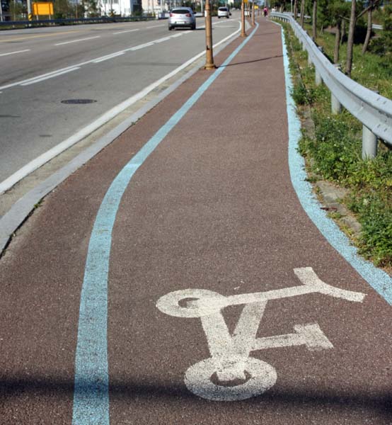
After a bit of exploration to find a 1:150 000 scale map book, I headed for the Han river, with the aim of picking up the cycling trails that follow the river to escape the urban sprawl of 10 million people. I thought I'd worked out a straight forward route, but after a while hit a guardhouse, and discovered that a fair portion of south central Seoul is occupied by the US army, who don't take kindly to cycletourists passing through without high level security clearance. After some frustrating climbs and false turns, I finally made it to the Bangpo Bridge and the cycle trail.

This was a revelation - a 5m wide trail, 2m each direction for cyclists and a metre for pedestrians. Taking advantage of this recreational cycling bounty seemed to be a fair portion of that 10 Million people, on bikes ranging from folders to serious full suspension rigs (to be frank, I never found any cycle trails that justified these bikes, but they seemed to be common), not to mention scooters, roller blades, and high class running shoes. Rather than climb to the vehicular Bangpo Bridge, I could cross the Han on a cycle only bridge at river level. I headed East on the trail, passing all sorts of weekend events: fun runs, picnics, baseball games. There were plenty of food outlets to restock at, and frequent toilets, water fountains and bike rental places.
Autumn flowers added a TDF dimension to the ride
I passed Gangnam (the affluent home of
Gangnam Style, which might explain why Korean recreational cyclists in this area were impeccably lycra'd) and a path side bike gear market.
I soon crossed back to the north side on the high Paldang bridge and stopped for lunch of skewered pancakes under a riverside awning.
Then the route picked up an old railway line past the Paldang dam. Although Jan had supplied me with a route guide following the Han river trail all the way to Busan, he'd suggested as more interesting a route crossing the mountains to Sokcho on the East coast, so I headed north on a road that although bearing a fair bit of weekend traffic, had an adequate shoulder.
After being accosted by two seminarians (actually drumming up custom for a restaurant, I think) I made a stop about 60 km riding from Seoul, at an upmarket riverside hotel. The family had spent time in South Africa, so dinner was a Brai, making for a truly multicultural evening.
A nice Korean touch, though was the cotton gloves to prevent your fingers from being burnt by the hot meat, with disposable gloves on top to stop the cotton gloves from getting greasy.
Next morning I headed up the river in a cool fog, initially resigned to riding on a busy 4 lane expressway, but after a few kilometers discovered the Gangchon cycleway running parallel to the highway. Following Jan's advice, I kept on the true right of the valley past the Chuncheon Dam and lake. At this point I met Mr Kim who was keen to escort me up the cycle path and point out the sights - given that Kim is the most common surname in Korea, and Smith the most common Anglo-Saxon surname, there seemed something very appropriate about Mr Kim and Mr Smith riding together.
By now it was a fine sunny day, and plenty of cyclists were out on the path which ran beside the calm lake, reminiscent of Lake Como in Italy. The path was frequently cantilevered out over the water, necessitating warning signs.
We met two Dutch cyclists traveling the other way, also following Jan's directions, which gave me some confidence about the route - although these were the only westerners I saw between Seoul and
Sokcho on the east coast - one thing that surprised me was the lack of western travellers.
At the park by the
Animation Museum, Mr Kim and I shared his coffee and my chocolate bar. (Why an Animation Museum? Think about where all the animation cels for the Simpsons, Futurama, etc are done...). I learned that Mr Kim and I were a similar age, but he had a much stronger climbing record, having climbed in Nepal, including Everest, and showed me the scars to prove it.
Regretfully, Mr Kim had to turn off to complete his circuit through Chuncheon, and I headed up valley. Crossing a pass, I got a reminder of how close to the border I was, when I saw this structure.
The big blocks are designed to topple onto the road and block North Korean tanks when the explosive charges in the small supporting blocks are fired.
Near Hwacheon, cycling and walking paths ran through fields of yellow flowers, and a stall gave out cups of tea brewed with the flowers.
Hwacheon was seething with 18 year old national servicemen on weekend leave, taking me back to 1971 Waiouru. I spent a while trying to avoid a hotel that was also catering for the sex trade, but it looked like the national servicemen were actually more heavily patronising the "PC Bangs" - computer games rooms that are a feature of every Korean main street. At the hotel I selected, the woman figured out how to explain to me where I should store my bike overnight.
Next morning was cooler, and I had to watch for ice on the trail as I followed along the misty river.
I warmed up as I climbed to the 2km Haesan tunnel. I'd been warned that tunnels were a feature of Korean highways, and an issue for cyclists. However Haesan, and the subsequent tunnels I rode, were well lit and had adequate shoulders, so with a tail reflector and a flashing rear light I felt fine.
The road dropped down through forests starting to show their autumn colour, to the Peace Dam. On the way, a sightseeing taxi stopped to chat - the woman asked me "how do you know about this place? Most Koreans don't even come here!". The Internet has a lot to answer for.
The Peace Dam is an interesting structure, as this photograph of the
upstream side shows.
Notice something odd? Remember this is the upstream side, which in most dams is usually filled to near the top. Here, forest, roads and buildings are sited below the top of the dam, and there appears to be no intention to fill the dam. The answer lies upstream, in North Korea, where a large dam is perceived as a threat. If by accident or design, the water from the North Korean dam was released, the result could be a flood that would extend down river to Seoul. The Peace dam's sole purpose is to intercept that flood, and protect the cities downstream.
I rode on to the small town of Bangsan, stayed at a small hotel and walked around the village which features a pleasant river, and several traditional porcelain furnaces.
Next morning my hosts farewelled me, and I headed north through Haen and back down the river to rejoin the main highway at Wontong where I stayed. The next morning marked the end of the golden weather, with a drizzling rain as I headed up the expressway towards the coast. I had a moment of panic when the expressway headed into a series of tunnels, with a large "no cycling" logo. However I eventually spotted the "cycle path" - the old main highway, which has been preserved with the addition of cycle logos.
With the adapted Crocodile Dundee line of "Call that a cycle path? THIS is what I call a cycle path..." going through my head, I had a pleasant ride up the forested gorge before rejoining the main road. Although I had to ride the highway from here, construction of a cycle path was already under way, with an information board showing cyclists next summer heading up valley shaded by vine covered pergolas that were being erected over the route - a nice touch that
Nga Haerenga might want to consider for a Marlborough Vineyard ride.
At the turnoff to the Misiryeong Tunnel to Sokcho and the east coast, I met three young radiographers fixing a puncture. After a chat about cycling, I headed off, confident that they'd be passing me soon, which they did.
Through the tunnel, the sun came out and the road descended swiftly to Sokcho, with the jagged "dragon back" peak of Ulsanbawi in Seoraksan National Park towering to the south of the road. I spent the afternoon exploring Sokcho city, taking the ferry across to the fishing village of Abai Island which used to be a picturesque fishing village until an expressway overpass was built over it (Basin Reserve, anyone?). The ferry is a nice bit of technology - the ferryman pulls on the cable with a special hook to move the ferry across, and since the ferrymen are getting on in years, there are spare hooks for passengers to help out with.
From Sokcho, I rode the short distance inland to Seoraksan National Park, where it looked like a fair proportion of Korea's 50 million people had rolled up to see the autumn colour.
The numbers eased off a little as I headed up the trail to the top of Ulsanbawi - many people made their days objective to queue for a chance to rock Heundeulbawi, a finely balanced boulder.
But when the trail reached the final cliffs leading up to Ulsanbawi, waiting for traffic jams to clear provided frequent excuses for me to stop and catch my breath.
Finally on top I could get the traditional photograph with the Korean Taegeukgi flag (I'd inadvertently forgotten to bring an NZ flag for the occasion) and look across to the road that I'd cycled down the previous day.
Ulsanbawi's origin has echoes of our own Taranaki; Ulsan was apparently a mountain that traveled north with the aim of joining a prestigious mountain range on the Chinese border, but when he arrived there wasn't any room for him. In a huff he headed south again, but after his exertions fell asleep at Seoraksan and has stayed there ever since.
A nice application of mobile technology was the QR codes on emergency points along the trail - if you're in trouble, scan the QR code with your smartphone, and your location will automatically be transmitted to SAR.
Koreans are enthusiastic photographers, and appreciate others' photography. I spent a while composing this shot of a temple roof with autumnal vines draped over it. Just as I was about to take the final shot, a passer by thrust their mobile phone into the shot. Bemused, I decided to take it as a complement to my choice of composition.
I lodged at a hotel near the park entrance, so next morning was ahead of the crowds as I headed up the valley to Geumganggul, a Buddhist hermitage cave half way up a rock face. The resident monk appeared to have fled the crowds, but his sleeping platform, with only some wire mesh protecting him from a several hundred metre drop, gave some idea of the lifestyle.
In the afternoon I biked back out to the coast, and headed south, doing my best to avoid the main highway by keeping to side roads and cycle paths. Folding bikes are popular in Korea, and I'm sure Dahon and Brompton devotees will be pleased that the bike path markers of Naksan have eschewed the normal full-sizist bike path symbol in favour of a folder-friendly version.
My stop that night was in the rather prosaically named fishing village of "38", so named because it sits exactly on the 38th parallel, the original demarcation between North and South Korea.
The red sunrise is almost a symbol of the east coast, and helped me get going next morning, but the after affects of a dodgy Bibimbap (fried egg on stir fry) kept my energy levels low, so I stopped at Junminjin, where a medium sized ship has been dragged onto a hilltop to make a hotel. Needless to say, I stayed at one of the standard 30000 won hotels on the beach below.

Although the coast was very pleasant, it was becoming hard to avoid periodic stretches on busy highways, so I decided to take a bus back over the mountains to rejoin the Han River Trail. At Donghae I located the bus station and enquired about buses to Chongju, on the Han river. The ticket seller and I had an "if I were you, I wouldn't start from here in the first place" conversation, the upshot of which was that my best plan was to start by getting a bus back to Gangneung, 50 km back up the coast. This was fine: the bus left in 15 minutes, and the driver happily stowed my bike in the cavernous cargo hold. At Gangneung, I enquired about buses to Chongju - "sure, there's one leaving in 10 minutes". I bought a ticket, found the bus, loaded my bike and settled back in a comfortable window seat, congratulating myself on mastering the Korean bus system. It was only then that I looked more closely at the ticket, and found that my Kiwi accent had betrayed me, and I was on my way to Cheongju - a different place! As we crossed the mountains, I divided my time between appreciating the multicoloured forests the road passed through, and planning alternative bike tours from my new destination. However near Wonju we stopped at a rest area, that I realised was relatively close to the Han river, and decided to de-bus. Helpful folk at the rest area gave me advice on which road to follow, but in fact a few hundred metres from the rest area I stumbled on yet another brand new cycle trail.

This led painlessly down to the Han River trail, and a hotel at the small town of Buron. At the local school, the Buron soccer team were playing a visiting team, and the ubiquitous Mr Kim invited me to join a group of Buron supporters, who were dividing their attention between the match and the consumption of rice wine and barbequed chicken.
The rain returned the next day, and kept up as I sloshed down the River Trail to Yangpyeong, passing a few dedicated cyclists in plastic ponchos. At the hotel in Yangpyeong, I was grateful for the traditional ondol underfloor heating - I could dry my wet gear by just laying it out on the floor.
The last day into Seoul was brilliantly fine but cold. The trail followed an old railway line, on a level gradient with numerous tunnels and causeways. An interesting prohibition on the Han River Trail is dogs, although this young puppy wasn't old enough to read the sign, and was keen to run away from home.
When I reached the urban area, I decided to take a different route into the centre, following the bike path that leads up to the Cheongyecheon, a reclaimed stream that flows through central Seoul. As I followed up this path, I stumbled on a dance band playing in the shelter of an overpass, with scores of people of all ages (and even a cyclist in Lycra) joining in.
Unfortunately the actual river path eventually becomes pedestrian only, so I had to take to the street running parallel to the river, but with patience and a bit of inventive interpretation of traffic rules I made it back to Namdaemun and my hotel, to switch into conference mode for
WIS/COLLNET meeting that was my official reason for being in Korea.
So is cycletouring in Korea worthwhile? Definitely yes - cycle paths are being constructed at a rate that puts Nga Haerenga to shame, and with a good map you can generally identify routes that use low density secondary roads. Getting out of big centres such as Seoul can be a problem, although I subsequently discovered that you can take bikes on the Metro, which could an option for escaping the centre. Language is less of a problem than it might seem - road signs are almost always in western script as well as Hangoul, and many people understand some English. Accommodation in traditional "motels" (more like European basic hotels) is ubiquitous, standard and economical. So if you're looking for a cycle touring adventure, why not give Korea a go. You might even enjoy the Kimchi!
Google Map of the bike route


