Friday, March 6, 2015

Hybrids in the hills: the Pureora Timber Trail

"How are you getting on riding that bike?" Marg was asked several times, The bike in question would have been the technological envy of an early 1990s mountain biker: front shocks, V-brakes, gears down to 1.8m development (that's the equivalent of a 22" penny farthing, for those of you wedded to imperial measurements), and 42mm tyres on 29er rims. The question, though, was most likely prompted by the hybrid bike's sit-up, citybike configuration, which implied that it was more at home conducting Marg to her Willis Street law office than tackling the Pureora Timber Trail.

Through somewhat convoluted logic, I was also riding my hybrid rather than a mountain bike - the CT scan reports on my spine had reinforced my specialists advice that mountain biking was OK, so long as I didn't do the sort where I fell off. Given that single track always involves the risk of a fall, I'd sent my mountain bike off to a South Island retirement home, looked after by my daughter and a territorial mastiff.

We started by parking our car at Ongarue, and got shuttled up to Pureora by Ian and Ros of Timber Trail Shuttles, getting a full briefing on Pureora gossip as we went. The first section of the trail winds between the tall trunks of a remnant of Te Nehe-nehe-nui, the "great forest" that covered the central North Island. This particular remnant was saved by protests in the 1970s. A short detour leads to a 1930s bulldozer, a reminder of the machinery that harvested this forest. A bit further on, the trail breaks out into the barren waste of recently felled forest, a further reminder of the industrial forestry that has replaced much of Te Nehe-nehe-nui.
Cyclists contemplate reviving the 1930s bulldozer to give them a tow up Mt Pureora
Freshly felled forest leading to Mt Pureora
Soon the climb started in earnest, entering the cloud forest around Mt Pureora at the first shelter, where we paused for a view. To be honest, from here on my pauses became more and more frequent, taking the opportunity to appreciate the green labyrinth of the cloud forest at every km post, conveniently placed to lean my bike against. Rather than hang around, Marg headed up the 40 minute track to Pureora summit, meeting me again at the 14km high point for lunch.
View north west from first shelter.
Hybrid pauses at a convenient km post to contemplate cloud forest
It was a bit of a relief to start descending, though narrow tyres meant that I had to pay attention to the dips and bumps. Occasionally an orange marker indicated a rough side trail out to a view - or cellphone coverage.

Soon we reached the first of the suspension bridges. These are a highlight of the trail, making the crossing of bush clad valleys effortless. They are amazing engineering achievements, providing rigid bike paths with only a spidery network of cables, seemingly resistant to wobbles caused by riders or wind.
Marg crosses a suspension bridge
"Unless you suffer from vertigo, it's worth stopping in the middle to appreciate the forest views" - Jonathan Kennett, New Zealand Cycle Trails
Another innovation on the trail is the "stump house", a possible precursor of the "Small House" movement. A three man team was working in the area when one of their number returned from a trip to town with his bride, and demanded the exclusive use of the whare the team had been using. The two bachelors hollowed out a stump, fitted double bunks, and apparently pursued a comfortable life for the rest of their contract.
Inside the "stump house"
After Harrison's shelter, the trail followed forestry roads until we reached the turnoff for Black Fern Lodge, about 7km off the main trail and currently the only full accommodation at the mid point of the trail. Our decision to ride the trail over Sunday/Monday was due to Black Fern being booked out for all the Saturday nights through to winter. I'd stayed there on a previous trip, but had only biked out to the trail, not in. My memories of a brief sweeping descent turned out to be optimistic - instead we had a long steep grind, with the occasional bizarre "encouragement" installed by the Black Fern management, and provoking mutterings of "why didn't we just stay at the campground".
An eerie face looms up out of the gloom, urging us "don't give up"...
Eventually we reached the ridge top, and dropped down steeply to the Lodge, where Maria had a prepared dinner waiting for us to pop in the oven. It was warm enough for Marg to dive under the waterfall (now a trendy wedding venue) just upstream of the lodge, though I took the easy option of a shower and a lie-down. The delicious dinner washed down with a couple of Stella Artois at a picnic table with views of the sun setting on the bush clad ridges restored our equilibrium.

Next morning we did our best to knock off the delights in Maria's breakfast hamper, then loaded our bikes aboard Eddie, the Lodge's pickup truck, which owner Kerry has festooned with bike racks to get guests back up to the ridgeline. From here, the ride out to the trail was much more pleasant than the grind of the previous night - or at least it was once we'd mended the puncture on Marg's bike. We took a brief look at the Piropiro campsite, occupied by a single car tourist - there are rumors of a Glamping site being developed here, which could provide an attractive alternative for the mid point stay on the trail.
Loading up Eddie
Riding out to the main trail
The second day's trails are easier - wide hard packed surfaces where the hybrids came into their own. More suspension bridges, including the biggest span of 141m across the Maramataha Valley. There was a moderate climb through native forest before we reached the terminus of the Ellis and Burnand bush railway that extracted timber from 1914 to 1958. Marg remembers the Ellis and Burnand Mill at Otorohanga from her childhood, but the company had sawmills and bush railways penetrating many parts of Te Nehe-nehe-nui. While we might mourn the lost forest, the bush railway makes a great bike trail, gradually wending across the ridges and descending to Ongarue. The frequent cuttings with their overhanging bush seem like tunnels.
Marg contemplates a change of wheel at the tramway terminus
Marg emerges from a cutting
A DOC oral historian has done great work preparing information signs, so the trip becomes a journey back through time, learning about the establishment of No 11 camp, then No 10 (allegedly the coldest of the camps) and on to the spiral railway that allowed the "lokeys" - steam locomotives - to make the final climb from Ongarue to the bush clad plateau. The information signs are peppered with anecdotes - such as the pay clerk's horse that bolted on the ride in, not to be found for two weeks, miraculously still bearing the saddlebags laden with timber workers pay packets!
you have been warned...
Marg emerges from the spiral
Down in the valley we skirted cattle and deer fences on a firm gravel trail (occasionally punctuated with rabbit holes) before coming out on the road for the last 2km into Ongarue, cold drinks, and the drive back to Wellington.
Holes dug by seditious rabbits (probably with IS links) subverting John Key's vision of a National Cycleway
So are hybrid bikes practical on the Timber Trail? Certainly. A true mountain bike would have been better for blasting down the single track on the southern side of Mt Pureora, and we might have been less sanguine about this section in wet weather. But for most of the trail the hybrids were fine, underscoring the lesson that the best bike for a ride is the one you've got already.

Friday, January 2, 2015

eMotoring the Motu - a father son ride

EBiking Eastland - you've got right of way - though the chance of another vehicle is pretty low!
There are advantages to having a son. There's the opportunity to pass on your DNA, and any wealth that you neglected to expend on overseas trips and fine dining. But at the checkin for our Gisborne flight, the big advantage was that with my eBike box weighing in at 29kg, Martin's bike box was only 19kg. After a quick component redistribution, we achieved the 23kg limit on both boxes, and we were on our way. "Though we can't guarantee we can get them on the Beechcraft..."  So I was glad when I peered out the window to see the last bike box disappear off the luggage trolley.

After a couple of aborted landings ("birds on the runway") and sightseeing passes over Young Nick's Head, Martin was on his way into central Gisborne to collect my eBike battery (sent by courier since airline dangerous goods regulations ban it from flying) and the all important stop at the supermarket to stock up on dinner ingredients and cask wine, while I reassembled my bike and enjoyed a coffee. Then we headed out. The planned route to the Bay of Plenty was following the Kennett's Classic New Zealand Cycle Trails "Rere Falls" trip, first of all heading for Eastwoodhill Arboretum on quiet roads to the west of the main highway, then up past Rere falls to cross the main highway at Matawai, climbing to Motu and the old Motu Road that follows the Waiaua river down to the Bay of Plenty at Tirohanga, finishing with the Dunes trail along the coast to Opotiki.
Trip Advised lunch stop

But first the lunch stop. We paused by a likely looking vineyard in Bushmere, chatted to a bloke on rideon lawnmower about the virtues of the restaurant compared with the ones up the road. Martin checked Trip Advisor - scored 5 out of 50 Gisborne restaurants, so we headed in. Would you like a wine tasting? Why not! Rideonmower bloke reappeared in a new shirt and guided us through a selection of Bushmeres finest, leaving us to enjoy our meals while he got back to the next paddock. That set us up for the next few hours riding to Eastwoodhill, which was closed (December is winter after all in eastland) but gave us the chance to pedal round among the towering podocarps before going back down the road to our accomodation "Ngatapa Retreat" otherwise "Mary's cottage", where our host Marija had left us an amply stocked fridge complete with a couple of cold beers which we were enjoying on the deck when Marija rode up sidesaddle on her quad bike. "Got worried when I saw you ride past - must put a sign out some time". Martin cooked dinner while we were entertained by Marija's grandson,  4th ranked NZ trail bike rider, practicing for the Nationals with spectacular jumps along the treeline above us.

Next morning a generous cooked breakfast and assembling a packed lunch made a small dent in the fridge supplies, and we were away. We had a scrog stop under the mini Niagara of the Rere falls, then followed the sounds of the truck mounted boom box at the all weekend party on the Rere Rock slide.
Party time at Rere Rock Slide
Partygoers on boogie boards and inner tubes hurtled down the 50m incline into the pool below - I decided this wasn't a good recreational choice for someone with bone disease so we carried on west and then north on beautiful winding roads with gentle gradients and the occasional sunshower to cool us down. Martin's white top started its conversion to beige from the mud thrown up from the wet road.
White to Beige in one easy  bike ride
After seeing a total of 5 vehicles since Rere, it was a bit of a shock to reach SH2 and turn east for Matawai on the busy main highway. We managed to achieve the secret knock on the private entrance to the Matawai hotel, and cook, receptionist and general dogsbody Karen ushered us in to our accommodation before dashing off to organise dinner. At this point I realised I'd left behind the key that allowed me to remove the eBike battery for charging in our room; but there was a simple solution - I was allowed to plug the bike into the Xmas lights.
Away in the manger, the eBike did charge...
After a  breakfast tutorial on  beekeeping from a fellow guest, we headed north off the main highway for Motu. Harry Potter fans will be pleased to hear that Matawai features a "Grieffondor" house. At Motu we caught up with Karen again - walking her horse in a paddock by the new cafe she's planning to open soon - this will be a good refueling stop for cyclists heading for the Motu Trails. We saw traces of the railway that was supposed to connect Gisborne to the Bay of Plenty, but didn't get beyond Motu.
Climbing to the Old Motu Coach Road
Back on to gravel, we climbed to the junction with  the Pakihi track, where a shuttle was dropping off mountain bikers and walkers. We kept to the road, the original1914 route from Gisborne to the Bay of Plenty, enjoying a descent through native bush with the odd farm.
Agricultural life on the Old Motu Road
We encountered a digger clearing a recent slip. At first we thought we'd have to clamber over the debris, but the digger driver quickly carved out a bike trail that we could ride through - now if only we could get that man working on the Petone - Ngauranga cycle trail!
Martin passes the slip
Old Motu Road bend
River crossing on the Old Motu Road
Dunes Trail
At the coast, we picked up the Dunes Trail - a series of gravel trails on boardwalks that avoid the main road into Opotiki. We hadn't had much in the way of lunch supplies, so we made a beeline for Opotiki's best (and only) sushi shop. Waiotahi Beach had a campground with a family suite - good thing we were a "family" . The surf in front of the campground was warm and inviting, so we plunged in. 

We'd originally planned two days from Opotoki to Katikati, where we were due to pick up our Coromandel car. But flat roads, a tailwind, and an aversion to biking through Tauranga lead us to renegotiate our pickup arrangements, and brother in law Alan agreed to pick us up from the Papamoa turnoff. At this stage the eBike had done 107km on one charge - a "record".
Opotiki to Papamoa turnoff: 107km, and 4/5 battery
A quick drive through to Whangamata saw us arrive at the same time as Marg driving from Wellington.

Having a son, or indeed any children, leads to a progression of experiences. I recalled three year old Martin moaning from the child seat that we were going too slowly over the Maungatapu saddle, and admiring his 10 year old skills on the Karori BMX track and skateboard ramp. But riding with an adult son is a special experience - I was not just riding with my son, but with a good "cycling mate". 

Wednesday, November 5, 2014

The Electric Cycletouring Acid Test

Heading down the Dovedale Valley, snowcovered Mt Arthur behind
Having acquired an eBike, I naturally wondered how it would cope with cycle touring? Would the battery last for a days riding? How easy would it be to charge the battery overnight?

Attending the 2WalkAndCycle conference in Nelson gave me the opportunity to find out. I hatched a plan to ride to Nelson, then join one of CANs post conference rides around the Great Taste Trail.

Having fully charged the eBike's battery, Marg (on Lucie, her trusty Tern folder) and I headed down to the BlueBridge terminal, to meet Russell, grappling with the long load of an A0 poster for his conference presentation. After an uneventful cruise, wandering the decks and breathing the unique mix of Cook Strait salt air and livestock truck odours, we emerged from the bowels of the Santa Regina and headed off along Queen Charlotte drive.
Russell's long load on the Queen Charlotte Drive
The eBike buzzed up the hills confidently and we cruised up the sound to Grove, which seems to be the cute letterbox capital of Aotearoa.

A stiff westerly had got up by the time we tackled the flats across Linkwater, so the eBike went in front allowing Marg and Russell to draft behind, though Marg found it a challenge drafting with the Tern's small wheels, and eventually headed out in front. We made our motel in Havelock in plenty of time for a post ride beer, minor bike adjustments, and dinner at the Mussel Pot.
Russell and friend, Rai Valley
The next day was potentially a test for the eBike - 74km, with two biggish climbs. The last thing I wanted was to be stuck between the Rai Saddle and the Whangamoa Saddle with a flat battery. But in fact the day went smoothly, with the eBike making it happily through the bush clad hills. We'd been a bit apprehensive about the Labour Day traffic, but heading west the road has adequate shoulders and the vehicles were generally following road code guidelines for passing distances. I did notice however that heading east, the shoulders are rather less generous, something to bear in mind when planning a cycle tour.

We stopped at Hira for a late lunch, the resident cat only too happy to help us with our chicken sandwiches. Then on to Nelson, where we picked up the Atawhai trail into town - Russell to the conference motel, Marg and me to catch up with old friends Mike and Patsy.

Cycling conferences are a great chance to recharge one's advocacy batteries, so the eBike got a bit of a rest while we debated mandatory passing distances, shared paths etc. A nice feature of this conference was the breakfast sessions, where early risers could join keynote speakers at a local cafe. One was at Lambrettas, which attracted me since a Lambretta scooter had been part of my two wheel evolution.
Lambretta meets eBike at Lambrettas
After the conference, I met up with the two day cycling group, and Ian kindly guided us out on the bike paths to Wakefield and Get Real Backpackers.
Coastal cycle path to Richmond
Trevor, our host, took us for a tour up the back fields, accompanied by Angel, a sprightly two year old dog keen to chase thrown branches.
Angel plots to stow away on Patrick's bike
The next day we headed back into Wakefield for a bakery breakfast which powered us up for the Dovedale saddle. The eBike coped with the climb along winding gravel roads through forestry land, then it was a fine run down through the Dovedale valley, which had several of us declaring it the "finest cycle touring in NZ" .

We stopped for a rest at the Dovedale Cricket pavillion. In the nearby churchyard was a memorial to Edward Eban, who died of injuries sustained on the Upper Moutere cricket field in 1908.

On we rolled down to Woodstock, passing a Landrover graveyard, and across the Motueka River to the quiet West Bank. Around lunch time I noticed a group of road workers in fluoro sitting in the shade of a tree by their truck. It was only after the calls and yahoos followed me down the road that I realised I'd biked past my companions having lunch. Time for another visit to the optometrist! At Ngatimoti we crossed back to search for the rumoured cafe, but it was closed, and we contented ourselves with a chat with a friendly member of the Ngatimoti Bowling club. At Riwaka the trail took a circuitous route to end up at the new cycleway clipped on to the Motueka River Bridge, and we finished the day's exertions with fruit icecreams at Toad Hall. The four day tour had also arrived, so we dined together at the Sprig and Fern.
Ice creams at Toad Hall
Helping with inflation issues on a canine carrier, Toad Hall
Sunday was the last day, and I decided to test the range of the eBike by heading up to Kaiteriteri before going along the coast back to Nelson. It was a good choice - following boardwalks and stopbanks along the shore then and easy single track route through the Kaiteriteri mountain bike park to a coffee and slice at a beach side cafe. Kaiteriteri seemed quiet, no doubt resting up for the boxing day invasion.
Coastal boardwalk to Kaiteriteri
Back in Motueka Patrick and I formed the rear guard of the two day excursion, and headed east. At Riverside Cafe, we were distracted by "Look, it's Patrick" from a table of Wellingtonians, but decided to press on in search of the perfect sandwich.
Leaving Riverside Community
About here the trail designers must have decided that cyclists were in need of a variation from flat gradients, and took us on firebreaks to a high point at the top of Harley Rd. The eBike coped fine, but I did wonder what the reaction is from those expecting an Otago Rail Trail topography.
Summit of the Harley Rd deviation
At Tasman I discovered a fine sandwich (eschewing the attractive looking "cyclists slice"), and Patrick discovered a puncture. After several immersions of the tube in a water bath kindly provided by the storekeeper, we were on our way, and the countdown to the 4pm sailing of the Mapua Ferry began, Initially the refrain was "lots of time to get there by 4pm" but as the wind rose, and the trail  took increasingly less direct routes,  I cranked up the eBike to maximum power settings, and we arrived on the jetty at exactly 4pm - to see the ferry part way across the channel to Rabbit Island. It turned out the schedule was merely a guide, and on his return the skipper agreed to take us across, despite the challenge of maneuvering the ferry through the wind driven waves. Punters wanting a return trip were out of luck, though - he wasn't certain he'd be able to make another trip. At Rabbit Island we quickly ran the bikes down the gangplank and up the soft sand.
Alastair doing a McArthur imitation on Rabbit Island
Crosswinds plagued our progress along Rabbit Island, and we were glad to head inland and across the causeway to pick up the final section of the trail into Nelson. I was made welcome again by Mike and Patsy, just returned from a steam boat excursion on Lake Rotoroa, and the next day took the bus and ferry back to Wellington.

So is cycle touring on an eBike feasible? Certainly. Admittedly, I'd kept the power control on the most economical setting, and just used the hand control for a power boost on hills. But the last day was over 80 km, and the battery was still showing 3/4 full (though I suspect the drop from 3/4 to empty is more rapid than from full to 3/4). I didn't have problems with charging, though it helped that I'd bought a double plug, and that the eBike's battery is removable.

So even now, the next electric cycle tour is being plotted... watch this space.

[More photos of the trip on Google +]

Thursday, October 23, 2014

Go north, old man?

Aquatic life off Poor Knights Islands
When we decided on a road trip around Northland, we discovered that a surprising number of our contemporaries were established in the winterless north: Like the snowbirds of the US, who abandon Chicago for Florida, Kiwi baby boomers head over the Auckland harbour bridge and don't look back. Mind you, we discovered that Auckland's urban sprawl is hot on their heels, as tastefully landscaped housing developments spread north across the farmland.

First stop was an old school friend of Marg's, settled in a cliff top house on the Whangaparaoa peninsula. Helen and Jim had a great view north, fishing and swimming from the beach below their house, but Jim's road cycling group are finding that their morning rides are becoming more less enjoyable as they coincide with the commuter congestion.

We went on to visit Bob and Helen, who have for years pursued a nomadic lifestyle (perhaps due to Bob's former existence as a sea captain) and have gone from a comfortable Remuera town house to pioneering a lifestyle block near Warkworth. We got a tour of the house site - well chosen in the shelter of a hill  to the north, but not so high as to block the winter sun, covenanted block of native forest blocking the prevailing westerlies, and a restful view south up a rural valley.

We walked Warkworth, a transport nexus in the days of coastal scows, saw the Jane Gifford heading off with a cargo of tourists, and admired a charming steam launch moored on the quay.
On to Whangarei, to catch up with Brian and Sue. Brian, although an engineer by profession, is a serial lifestyle blocker: set him down in any city, and within weeks he'll have acquired 10 acres of land, 30 head of sheep and a shed full of agricultural equipment. The Whangarei estate was impressive - a relationship with a local digger driver with access to large rocks had resulted in a small lake with islands, and the cantilever framed shed could have been used for country dances in the days when that was fashionable. They were pleased with the move north - Sue felt the crux had been a business trip to the balmy north "I got back to Wellington - and it was SNOWING".

We had arranged a trip out to Poor Knights islands with Dive! Tutukaka. Poor Knights, about an hours boat run off the coast, is a cluster of pinnacles, with steep rock faces dropping straight into the sea, and currents connected with the Australian coast that result in occasional geographically confused tropical fish enhancing the fishlife of the marine reserve, making it a mecca for divers and snorkelers
Waiting for the boat to depart, we discovered we had a special passenger - a Mollymawk being returned to sea after rehabilitation. The massive bird was housed in a comfortable cardboard box, but was let out for a stretch on the wharf, to the delight of passers by.

Once we'd arrived off the Poor Knights, in a sheltered spot by Rikoriko cave, the Mollymawk went on its way to a clicking of iPhones, and we donned heavy duty hoods, vests and wetsuits (OK, the warmth of the water is relative - it was still spring) and splashed in to a watery world of clouds of fish. The buoyancy of the wetsuits meant we couldn't dive, but the views as we explored along the edge of the cliffs was amazing. You could explore up narrow channels into the rock face, turning back to see the clouds of fish silhouetted around the entrance.

Over lunch back on the boat, the guides told us of the history of the island, how the resident iwi enjoyed a porcine monopoly after Captain Cook had dropped off some of his eponymous pigs, but lost both pigs and lives in a retribution raid.

Then we went back in for another spell of snorkelling, and I lost track of time, entranced by sights such as a green sea snake wending it's way through the seaweed, and was the last back on board the boat before running back to Tutukaka.

We'd ran out of friends to visit, but Paihia had plenty of motel vacancy signs, and the Outrigger seemed as good a choice as any.

One reason for visiting the Bay of Islands was the Twin Coast Cycle Trail - one of the Nga Haerenga cycle trails. It's not yet complete, and I'd found varying information on how much was open. We decided to start from Opua, where the trail starts in the back of the shipyards, and see what happened. The gravel trail up the Kawakawa inlet was fine as was the weather. The rail lines have been retained  under the gravel, and sometimes emerge to keep cyclists alert. At Taumarere bridge the cycle path clipon had just been completed so we could bike across what is supposedly the longest curved rail bridge in NZ - though I'd have thought Hapuawhenua rail viaduct near Ohakune was longer. On the other side, a group of rail enthusiasts were having smoko in their boxcar that had been shunted through from Kawakawa, and confirmed that the plan was to extend the heritage rail line through to Opua - though it's not clear how this will coexist with the cycle trail.
At Taumarere the cycle trail ceases, and a hilly 3km on the main road took us into Kawakawa, and the next section of the trail through to Moerewa.  Moerewa is definitely Tangata whenua country - no middle class flight from colder climes here. People say "kia ora" because that's how they say hello, not because they want to be bicultural. The United Tribes Confederation flag flew over a veggie patch, and the Marae  with its imposing archways is well maintained.
For the moment the cycle trail finishes here (though secondary roads would provide a good route through to the next completed section at Kaikohe) so we headed back the way we'd come, eating our picnic lunch in the Kawakawa domain while the guys with the ride-on mowers waited patiently for us to finish.

We still had the afternoon, so decided to do the Kaikohe-Okaihau section as a vehicle swap - Marg dropped me at the Kaikohe end, drove around to Okaihau, and we passed in the middle. This section has been established for some time, and follows the route of the Okaihau express, immortalised by 1950s folk singer Peter Cape. There are good informational signs, a tunnel long enough not to be able to see the other end, small mountain bike tracks branching off the main route, and a good view of Lake Omapere, where "The fireman takes the bucket, the driver takes a swim".
Next day we tackled the "Full circle walk", which connects bush and coastal trails with the ferries, enabling a circuit Paihia - Opua - Okiato - Russell. Another brilliantly fine day (though the locals were as surprised at this as we were) as we walked along the beach to Te Haumi Bridge, then took to the bush track sidling and dipping into bach bordered beaches.
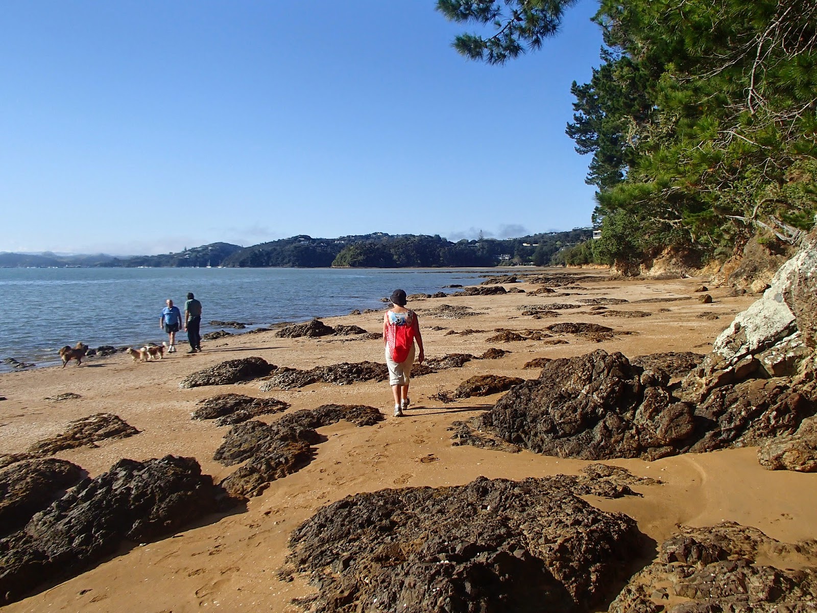
At Veronica Point we climbed up to a solidly constructed viewpoint, then dropped down to the wharf at Opua. With a boat every 10 minutes one can be relaxed about the schedule, and soon we were climbing up the road to the site of NZ's first capital - not a lot to see other than the well that provided the first legislators water - then join the Okiato to Russell walkway. this actually takes about three hours, so to avoid distress the signs simply tell you how long it is for the next section, so it took us a while to realise that it was going to be late lunch in Russell. Fortunately a swim at Pipiroa Bay set us up for the next few hours of up and down walking through attractive Kanuka and Kauri.

We made it to Russell and settled down at a waterfront cafe. Breathless cellphone calls brought the news that the auction of my mothers house in Auckland  confirmed the inflated state of the Auckland property market, and that we could probably afford to splash out on an extra cake and coffee.
I'd also been keen to try kayaking, so next morning Marg consented to join me in a double kayak up the Haruru River, to nose up to the rather grubby water pouring over the falls. Then it was south on toll road, and a flight back to Wellington for me.

Had I been tempted by moving to the winterless north? When I got back to Wellington I collected the folding bike, put it on a luggage trolley, found a taxi and loaded the bike in. When I turned around, the luggage trolley was being blown by the gale towards Cook Strait. It was good to be back to a place with real weather.

More photos of the trip on Flickr...